-
-
First Aero Survey Co., Ltd. has a lot of experience and know-how related to the construction of 3D spatial information, including the establishment of V-World, a three-dimensional map service of the Ministry of Land, Infrastructure and Transport.
In addition, We have successfully carried out projects such as the construction of a Digital Twin for ECRD(Earth Core Rockfill Dam) and the creation of Virtual Seoul's 3D spatial information.
-
4 th
We will lead the transition to the future by securing digital twin technology,
a key element of the Fourth Industrial Revolution. -
-
Production of Digital Surface Model/ Digital Elevation Model
Can be used for topography and natural disaster analysis, etc
-
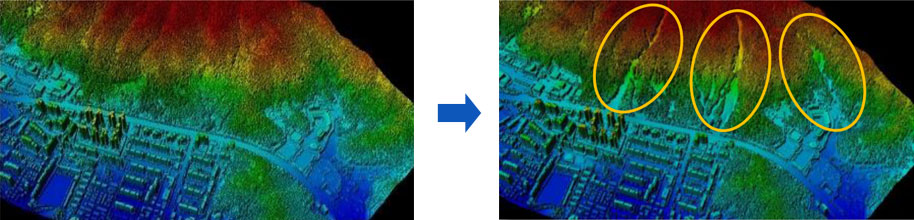
Calculation of surface and volume changes, such as accumulation and excavation, of essential use as topographic information when constructing image maps or 3D spatial information
Use as simulation data for the purpose of analysis of natural disasters such as flood inundation and landslides

-
3D Spatial Building Model
Experience in V-World deployment, high quality deployment in large regions
-
Optimization of construction through gradient image through exclusive domestic operation ‘Pictometry’
Self-developed SW enables editing of 'pinsets' only for errors, enabling efficient and high-quality performance
Have years of experience in building large-scale regions and related know-how
-
Interior Space Map Production
High-precision results can be used for simulation in preparation for terrorism
-
Large-scale indoor or underground space structures, movement lines, facility locations, etc. can be precisely measured and mapped using 3D.
laser scanning techniques to prepare for fire and terrorism, using simulations
-
3D Precision Road Map Production
Can be used to build autonomous vehicles and smart city infrastructure
-
Excellent precision applicable to commercialization of autonomous vehicles and building smart city infrastructure, which are future technologies.
Use of its own machine learning tools (Pix 4D Mapper) and classify buildings, roads, facilities, etc. by category.